Home /
Florence Travel Tips / Maps / Google Map's Satellite Image of Florence
Google Map's Satellite Image of Florence

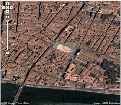
Google maps is really cool. Here is an example of what you can see. That is Piazza Santa Croce in the middle of the image (the light colored rectangle) - we will be staying on the south side. You can see the white marble of the top of the facade of the church to the right of the piazza. If you go to Google maps, click on the link that says "Satellite" on the right hand side, then put "Florence, Italy" in the search box.
Comments:
Last update:
What's New?
-
Florence Parking Guide & Map
Feb 23, 2026
-

Top Ten Luxury Hotels in Florence
Feb 9, 2026
-

Piazza San Marco
Jan 5, 2026
-

Piazza Santa Trìnita
Dec 2, 2025
-

Ceramics Fair (Fiera della Ceramica)
Oct 1, 2025
Top experiences in and around Florence:
© 2005-2026 florence-on-line.com | About | Glossary | Newsletter | Site Map
Some links to external websites may be affiliate links (hotel bookings, guide books, activities, etc.). Using these services helps to support our efforts here with no additional costs to the user (you!).
Some links to external websites may be affiliate links (hotel bookings, guide books, activities, etc.). Using these services helps to support our efforts here with no additional costs to the user (you!).